


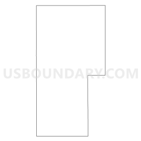
Tribune Precinct 3, Greeley County, Kansas
About
Outline
Summary
| Unique Area Identifier | 584902 |
| Name | Tribune Precinct 3 |
| County | Greeley County |
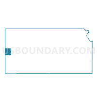
| State | Kansas |
| Area (square miles) | 420.23 |
| Land Area (square miles) | 420.23 |
| Water Area (square miles) | 0.00 |
| % of Land Area | 100.00 |
| % of Water Area | 0.00 |
| Latitude of the Internal Point | 38.49555270 |
| Longtitude of the Internal Point | -101.91329050 |
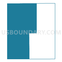
Maps

Graphs
Select a template below for downloading or customizing gragh for Tribune Precinct 3, Greeley County, Kansas


Neighbors
Neighoring Voting District (by Name) Neighboring Voting District on the Map
- Cheyenne 1, Cheyenne County, CO
- Kiowa 1, Kiowa County, CO
- Prowers 13, Prowers County, CO
- Richland Township Voting District, Hamilton County, KS
- Sharon Springs Precinct 2, Wallace County, KS
- Tribune Precinct 1, Greeley County, KS
- Tribune Precinct 2, Greeley County, KS
- Weskan Township Voting District, Wallace County, KS
Top 10 Neighboring County Subdivision (by Population) Neighboring County Subdivision on the Map
- Cheyenne Wells CCD, Cheyenne County, CO (1,343)
- Holly CCD, Prowers County, CO (1,283)
- Tribune township, Greeley County, KS (1,247)
- Sharon Springs township, Wallace County, KS (935)
- Sheridan Lake CCD, Kiowa County, CO (393)
- Weskan township, Wallace County, KS (330)
- Richland township, Hamilton County, KS (30)
Top 10 Neighboring Place (by Population) Neighboring Place on the Map
Top 10 Neighboring Unified School District (by Population) Neighboring Unified School District on the Map
- Syracuse Unified School District 494, KS (2,690)
- Holly School District RE-3, CO (1,394)
- Cheyenne County School District RE-5, CO (1,354)
- Greeley County Schools Unified School District 200, KS (1,247)
- Wallace County Schools Unified School District 241, KS (1,175)
- Weskan Unified School District 242, KS (310)
- Plainview School District RE-2, CO (295)
Top 10 Neighboring State Legislative District Lower Chamber (by Population) Neighboring State Legislative District Lower Chamber on the Map
- State House District 63, CO (69,709)
- State House District 64, CO (63,179)
- State House District 122, KS (19,688)
- State House District 118, KS (18,449)
Top 10 Neighboring State Legislative District Upper Chamber (by Population) Neighboring State Legislative District Upper Chamber on the Map
- State Senate District 1, CO (125,154)
- State Senate District 39, KS (64,662)
- State Senate District 40, KS (61,332)
Top 10 Neighboring 111th Congressional District (by Population) Neighboring 111th Congressional District on the Map
Top 10 Neighboring Census Tract (by Population) Neighboring Census Tract on the Map
- Census Tract 9586, Hamilton County, KS (2,690)
- Census Tract 9606, Cheyenne County, CO (1,836)
- Census Tract 9541, Wallace County, KS (1,485)
- Census Tract 6, Prowers County, CO (1,424)
- Census Tract 9601, Kiowa County, CO (1,398)
- Census Tract 9581, Greeley County, KS (1,247)
Top 10 Neighboring 5-Digit ZIP Code Tabulation Area (by Population) Neighboring 5-Digit ZIP Code Tabulation Area on the Map
- 67878, KS (2,436)
- 81047, CO (1,559)
- 67879, KS (1,247)
- 67758, KS (1,016)
- 81071, CO (334)
- 67762, KS (288)
- 80802, CO (238)